
|
Facility Name
|
Year Constructed | Curb? | Steeplechase information |
|
Cross streets or directions
Notes on unique situations and security problems Credited Manufacturer or installer Type of Surface |
Finish direction "Imperial" if track is measured in yards. | Number of lanes
Straightaway length
|
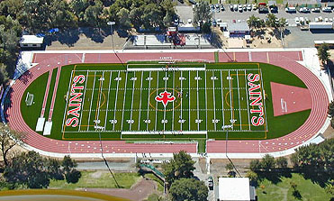
Aerial photo link courtesy of Google Maps
Altitude |

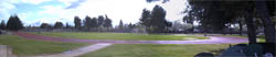
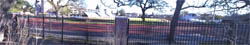
Sutter Creek |
|
Amador High School
|
No | ||
|
Sutter Lone Road and Old Madre Way
Black |
West |
8
100m
|
Aerial
Photo 1290 ft. |

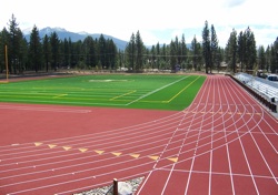
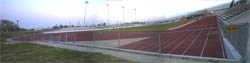
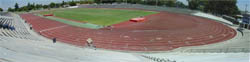
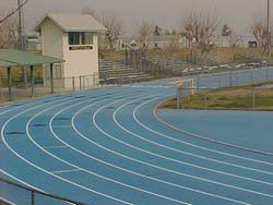
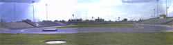
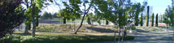
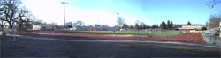
Chico |
|
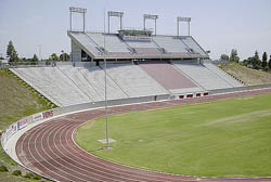
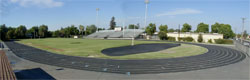
California State University, Chico
|
Resurf. 2002 |
Yes metal |
Yes Inside |
Warner and Legion
There are two tracks a block apart from one another, the college is the one to the Southwest with an inside steeplechase, wider turns and finishes to the North. Cal Track Rekortan Resurface |
North |
8
85m
|
Aerial Photo |
|
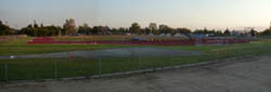
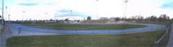
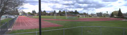
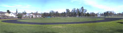
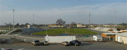
Chico High School
|
No | ||
|
Warner and Legion
There are two tracks a block apart from one another. This one is on the northeast corner and has tight turns and finishes to the south. |
South |
Aerial Photo |
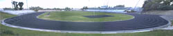
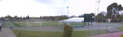
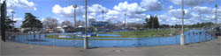
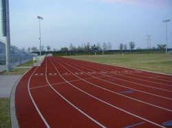
| Pleasant Valley High School | No | No | |
| Ceanothus Ave. south of
East Ave. Finish line offset 10m with the 180 yd. hurdle chute apparently also surfaced, possibly from a previous surfacing. Dark Blue |
South | 8
98m
|
Aerial photo |
Oroville |
|
Butte Community College
|
Yes Inside Slice | ||
3536 Butte Campus Drive, about 10 miles
north of town
Steeplechase finishes in reverse |
South |
Aerial Photo |
Altaville |
| Bret Harte High School | No | No | |
Murphy's Grade,
east of Highway 4, 49 |
East |
9 |
Aerial
photo 1510 ft. |
San Andreas |
| Calaveras High School | 2004 | No | No |
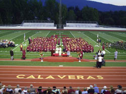
350 High School Street, north of Highway
49
Surrounding a fake grass infield. It looks like a 10 meter offset finish line, with 100m straight. Link to meet pictures. |
Northwest |
9
|
Aerial
photo
940 ft.
|
El Dorado Hills |
| Oak Ridge High School | 2005 | No | No |
 Silva Valley Parkway
and Harvard Way at the south end of the parking lot An interesting paint job, the relay passing zones are highlighted by triple wide lane lines. |
South | 8
100m
|
Aerial photo |
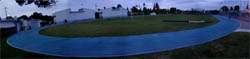
South Lake Tahoe |
| South Tahoe Middle School | 2008 | No | No |
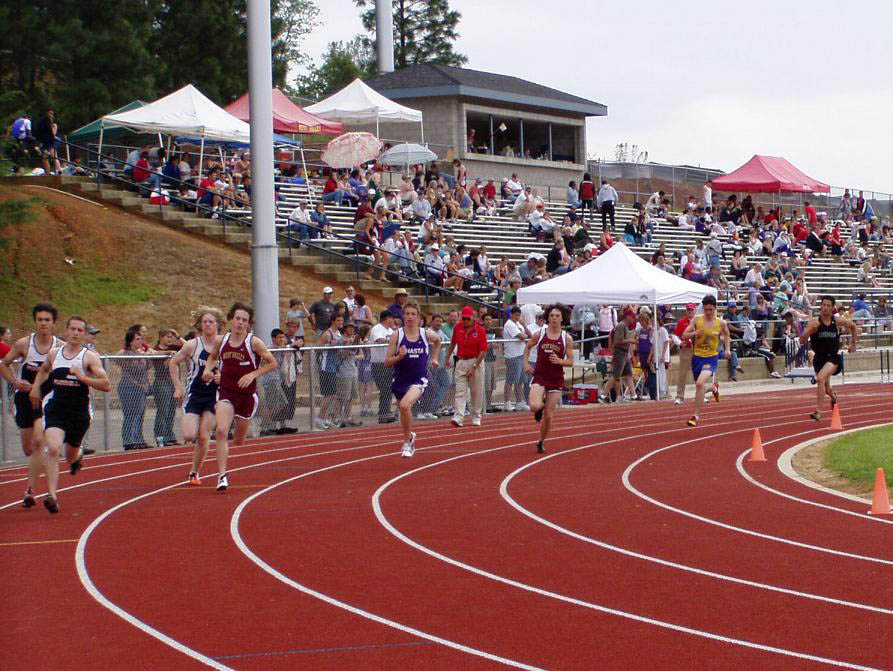
 Lake Tahoe Blvd and Al Tahoe Blvd. Lake Tahoe Blvd and Al Tahoe Blvd.This facility housed the track from the famous 1968 Olympic Trials that had been transported down the hill and installed here. That track was replaced in 2008, not because the surface had worn out (after 40 years) but because the subsurface had broken down causing bubbles. They don't make 'em like that any more. Unfortunately I am told this is covered in snow half the year and is not available during school hours during the school year--September to June. Tartan |
South |
8
|
Aerial
photo
6230 ft.
|

Clovis |
|
Buchanan High School
|
2007 | (Yes) metal |
No |

W.
Nees Ave. and N.Minnewawa Ave.
Big fancy stadium, seats over 8,000. Track has some noticible repairs made to west turn (which feel softer than the rest of the track). Apparently removes the curb, the previous time I saw it, curb was missing, but during a track meet it was there. Also has start lines marked for 40y and 65m. Southwestern Eurotan installed in 1999 replaced with Mondo |
Southeast |
9
93m
|
Aerial photo |
|
Clovis High School
|
No | No | |
 Fowler Ave. and Barstow Ave.
Wide turns. Not in the football stadium (north of it). Zaino |
East |
9
72m
|
Aerial photo |
|
Clovis East High School (known
as the Reagan Education Center)
|
1999 |
Yes metal |
No |
 DeWolfe Ave. and Ashlan Ave.
In the center of a huge campus, this actually has a real aluminum curb. Southwestern Eurotan |
East |
9
100m
|
Aerial photo |
|
Clovis West High School
|
1997 | No | No |
 E. Teague Ave. and Millbrook Ave.
Has ten lane marked sprint straight and an extra unmarked lane on first turn--evidence of a conversion from Imperial to Metric (see also at Roosevelt, Mt. SAC and West Valley College). Southwestern Seal Flex |
East |
9
95m
|
Aerial photo |
Coalinga |
|
West Hills Community College/Coalinga
Middle School
|
May 2002 | No | Yes slice |
 Sunset
and Harvard between Van Ness and Cambridge. !! High Security fencing surrounds
much of the stadium. Sunset
and Harvard between Van Ness and Cambridge. !! High Security fencing surrounds
much of the stadium.Cal Track Cal Trax IMS |
South |
9
100m
|
Aerial photo |
Fowler |
|
Fowler High School |
2006 | No | No |
 Main St. and Adams Ave. Separate from the Football Stadium Cal Tracks |
Northeast | 8
86m
|
Aerial photo |
Fresno |
|
California State University, Fresno
|
1996 | Yes metal/pipe |
Adjustable Inside |
Cedar and Barstow
They have taken the cheap way out to install their curb, it is made of galvanized pipe. Use this as an example of how to achieve the necessary curb at a reasonable budget. Southwestern Eurotan |
South |
9
95m
|
Aerial photo |
|
Edison High School
|
November 2003 | No | No |
E. California Ave. and Walnut Ave. (west
of the 99)
The drainage around this track seems deeper than normal though they attempted to be on track level. There are a couple of high, hard spots, marked with paint, on this track. I've seen these in a few other places but have no idea what could cause it. Cal Tracks |
South |
9
99m
|
Aerial photo |
|
Fresno City College, Ratcliffe Stadium
|
No | Adjustable Inside |
|
Blackstone Ave. and University 1 block
north of McKinley
Has space for an extra, unmarked sprint straightaway. Not used because there are some obstructions along the wall. ! This is surrounded by some difficult to climb fencing. If the barb wire were in place in the front, this would be difficult to get into--while it is missing, it is not. |
South |
9
93m
|
Aerial photo |
|
Fresno Pacific University
|
Resurf.2005 | Yes metal |
Adjustable Outside |
East Heaton Ave. and S. Winery Ave.
Wide Turns. I calculate the straightaways at 70m ! Security patrol caught me on the track and threw me out--private college. Cal Track Rekotan Overlay |
South |
9
70m
|
Aerial photo |
|
Roosevelt High School
|
Resurf.
2001 |
No | No |
Barton and Huntington
They replaced the old rubber asphalt with a new AW surface and converted it from Imperial to metric--with the tell tale extra lane in the first turn (see also Clovis West, Mt. SAC, Hancock and West Valley College). A nice facility but does show a residual crack in lane 3 from the previous badly worn track. This is so markedly improved it has been removed from the worst tracks list entirely. |
South |
9
100m
|
Aerial photo |
|
Sunnyside High School
|
No | No | |
East Kings Canyon Road and South Peach
Ave.
! Has spike topped fencing surrounding much of the track though there are some tall chain link portions. |
East |
9
93m
|
Aerial photo |
Huron |
|
Huron Middle School |
Yes |
No | |
 4th and Lassen 4th and LassenSoutheast corner of campus. Finish line offset 10m. 8 lanes on the sprint straight. Cal Track Cal Trax IMS |
South | 7
86m
|
Aerial photo |
Mendota |
|
Mendota High School |
No | No | |

Belmont Avenue between Dakota St. and
San Benito Avenue (Oiler Street) |
West | 8
100m
|
Aerial photo |
Reedley |
|
Reedley College
|
Yes concrete |
No | |
Manning Ave.& Reed Ave.
formerly Kings River Community College--Reedley residents hated that name so they changed it back to the original name for better civic identification. Take Reed to the north entrance, follow the road around back where track overlooks the river. Finish line offset 10m. Black. |
West |
9
99m
|
Aerial photo |
|
Reedley High School
|
1999 | No | No |
W. North Ave. and N. Hollywood
Replaced a semi-famous banked dirt track Southwestern Eurotan |
South |
9
100m
|
Aerial photo |
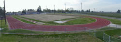
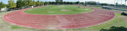
Sanger |
|
Sanger High School
|
Resurf.
2002 |
Yes concrete |
No |
14th Street & DeWill Ave.
A 10 lane, full circumference facility with a legal curb. Cal Track Cal Trax MS |
South |
10
91m
|
Aerial photo |
Bakersfield |
|
Bakersfield College
|
Yes | Yes | |
Mt. Vernon and University
! The razor wire fencing makes this quite difficult to get into. Finish line offset more than 10m. |
Northeast |
9
100m
|
Aerial photo |
|
California State University, Bakersfield |
Yes | Stationary Inside |
|
Haggin Oaks Blvd. & Camino Media ! Barb wire surrounds this track that is locked much of the time. |
South | 8
100m
|
Aerial photo |
| Foothill High School | No | No | |
| Park Drive and Eucalyptus
Dr. east of town It appears to be marked to run sprints backward, long chute beyond common finish. |
Northwest | m
|
Aerial photo |
|
Liberty High School |
2001 | No | No |
Has an inner curb that raises the track. Jewetta Ave. and Brimhall Road. |
South | 8
100m
|
Aerial photo |
Ridgecrest |
| Cerro Coso College | Yes metal |
No | |
 3000 College Heights Blvd.
|
East | 8 |
Aerial photo |
Taft |
| Taft Union High School | No | Stationary Inside grass |
|
San Emidio and 10th Streets Blue. Open 24 hours, lit until midnight, aren't small towns great? Steeplechase has grass runway. ! has barricades . |
South | 9 |
Aerial photo |
Corcoran |
| Corcoran High School | 1997 | (No) | No |
Whitley & Letts |
South | 8
94m
|
Aerial photo |
Hanford |
| Hanford High School | 1999 | Yes | No |
 E. Grangeville Blvd. and N. Kensington
Way E. Grangeville Blvd. and N. Kensington
WayFinish line offset 10m. 10 lanes on the home stretch. Pockmarked by lots of old repairs. A portion of the east turn have spots worn down to pavement, apparently in sections already replaced--the repairs wearing faster than the surrounding original surface. Black Southwestern |
Southeast | 9
91m
|
Aerial photo |
| Hanford West High School | 2005 | No | No |
 Lacey
Blvd. and Campus Drive Lacey
Blvd. and Campus DriveThe track is in back on the north end of the campus behind baseball fields. |
East | 9
94m
|
Aerial photo |
Lemoore |
| Lemoore High School | 1998 | Yes | No |
 Highway 198 & Lemoore Ave. Highway 198 & Lemoore Ave.This track really is colored Purple. There has been an all weather track here for quite some time, dating back to the rubber asphalt days. The western Pole Vault and Long Jump runways are inside the original curb for the long chute, possibly a full straightaway 220y. They used the original curb except on the east turn near the high jump, when the curb (shortening a previous imperial track) was replaced with a drain. Lots of the markings on the track, many in strange colors, are now faded and hard to see. Southwestern Eurotan |
West | 9
100m
|
Aerial photo |
Susanville |
| Lassen Community College | Old | Yes | No |
|
.
Rubber/Asphalt |
|
Map |
Ukiah |
| Mendocino College | Yes inside | ||
 Hensley Creek Road West
of 101
Steeplechase finishes on backstretch. |
Northwest |
8
100m
|
Aerial Photo |
Oakhurst |
| Yosemite High School | 2004 | No | No |
 Road 428 and Hangtree
Lane |
North | 9
100m |
Aerial Photo |
Merced |
| Merced College | Resurf. 1999 |
Yes concrete |
Adjustable, Inside |
M St. at Rensselaer Court (or G St.
and Yosemite)
Installed in 1995 ! I have been told access is restricted, but all that apparently means is they lock the turnstile. This is hard to find, northeast of the big stadium in the middle of the campus. Yellow Southwestern Eurotan |
South |
9
100m
|
Map |
Angwin |
| Pacific Union University | No | No | |
 Howell Mountain Road South at La Jolla Drive
No lane lines visible, suggesting this is an old Rubber Asphalt track |
South | 6 |
Aerial Photo |
Napa |
| Harvest Middle School | No | No | |
 Underhill Road and Old
Sonoma Road (track is on the east near freeway) Underhill Road and Old
Sonoma Road (track is on the east near freeway)Complete High School competitive facilities, including a hybrid (possibly added later) additional long jump runway off the northeast straightaway. Long straightaways. |
South | 8
105m
|
Aerial Photo |
| Justin Sienna High School | 2008 | No | No |
 Trower Avenue and Solano Avenue
Surrounding a fake grass infield. |
East | m
|
Aerial Photo |
St. Helena |
| St. Helena High School | No | No | |
 Grayson Avenue west of St. Helena Highway (Hwy 29) Grayson Avenue west of St. Helena Highway (Hwy 29)Meaning the only all weather track in the county is at a Middle School. Complete High School competitive facilities, including a hybrid (possibly added later) additional long jump runway off the northeast straightaway. |
Southeast | 8
105m
|
Aerial Photo |
Grass Valley |
| Nevada Union High School | 1997 | No | No |
Ridge Road North of Hughes Road (stadium
is behind school)
Southwestern Eurotan |
East |
9
|
Aerial Photo |
Auburn |
| Placer Union High School | 1995 | No | No |
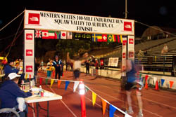
Finley St. and Stadium Way, East of
High Street
This is the end of the famous Western States 100 Southwestern Seal Flex |
Northeast |
9
|
Aerial photo |
Foresthill |
| Foresthill High School | Old | No | No |
 Foresthill Divide
Road and Sunset Drive, west of town |
North |
8
m
|
Aerial photo |
Granite Bay |
| Granite Bay High School | 2001 | No | No |
 Wellington Way at Grizzly Way, N. or
E. Roseville Parkway Wellington Way at Grizzly Way, N. or
E. Roseville ParkwaySurrounding a Fake Grass infield. |
South |
9
86m
|
Aerial photo |
Lincoln |
| Lincoln High School | No | No | |
 5th Street and L Street |
East |
m
|
Aerial photo |
Rocklin |
| Rocklin High School | No | No | |
Stanford Ranch Road at Victory Lane
(south or east of Park Lane)
I had reported it as Rubber Asphalt as I remember seeing it just a couple of years ago. Apparently it has been redone. It also looks like lane one on the sprint straight is in terrible shape. Watch this slide show and you'll get quite a tour of the track. |
South |
9
86m
|
Aerial photo |
| Whitney High School | No | No | |
 Wildcat Blvd. north of Whitney Ranch Blvd. Surrounding a Fake Grass infield |
West | 9
86m
|
Aerial photo |
Roseville |
| Oakmont High School | No | No | |
 Cirby Way opposite
Cottonwood Drive
Surrounding a Fake Grass infield. Two Long Jump Runways in the Southeast corner. |
South |
9
100m
|
Aerial photo |
| Roseville High School | No | No | |
 Berry Street north
of Tiger Way off of Atlantic Street
Surrounding a Fake Grass infield. There is a double ended Long Jump runway off the northeast corner near the chute. |
West | 9
95m
|
Aerial photo |
| Woodcreek High School | No | No | |
 Woodcreek Oaks Blvd.
and Trailee Court north of Jct. Blvd. Surrounding a Fake Grass infield. |
South |
8
91m
|
Aerial photo |
Quincy |
| Feather River Community College | Yes | ||
 Golden Eagle Ave. west
of Feather River Scenic Byway (Highway 70 and 89 north of town) Golden Eagle Ave. west
of Feather River Scenic Byway (Highway 70 and 89 north of town)The finish line appears to be offset by around 20 m. With few lane lines visible, this looks like an old Rubber Asphalt track. |
Southwest | 8 |
Aerial Photo |
Elk Grove |
Cosumnes Oaks High School |
2009 | No | No |

Lotz Parkway and Big Horn Road Surrounding a fake grass infield |
West |
m
|
Aerial photo |
Elk Grove High School |
2009 | No | No |

Elk Grove-Florin Road and Valley Oak Lane Surrounding a fake grass infield |
South |
m
|
Aerial photo |
Monterey Trail High School |
2009 | No | No |

Aubery Drive and Power Inn Road Surrounding a fake grass infield |
South |
m
|
Aerial photo |
Sheldon High School |
2009 | No | No |

Kingsbridge Drive and Calvine Road Surrounding a fake grass infield |
South |
m
|
Aerial photo |
Fair Oaks |
| Bella Vista High School | No | No | |
 Madison Ave. between McKay St. and Kenneth St.
Check out the history of the construction of this track, good pictures Southwestern |
South |
9
|
Aerial photo |
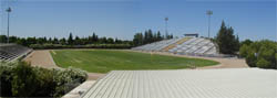
Folsom |
| Folsom High School | 2004 | No | No |

Prarie Canyon Road, south of Iron Point
Road just off the 50, near the river
Yes that's 10 lanes all the way around. Fake Grass infield. |
South |
10
80m
|
Aerial photo |
Rancho Cordova |
| Cordova High School | Resurf. 2004 |
No | No |

Chase Drive thru Hagen Park
After being on the Bottom 10 for a couple of years, they've finally done the needed resurface job and also re-did the curb to make this metric in the process. The picture to the left is from a meet before they repaired it.. Cal Track |
Southeast |
8
|
Aerial photo |
Rio Linda |
|
Rio Linda High School |
2007 | No | No |

Elk Horn Blvd. and Dry Creek Road Surrounding a fake grass infield |
East |
m
|
Aerial photo |
Sacramento |
| American River College | Resurf. 2005 |
Yes | Yes |
|
College Oak Drive south of Orange Grove
Ave., South Entrance
Has decent night lighting ! There is a turnstyle to enter, except it gets locked occasionally. Cal Track Rekortan Overlay |
South |
9
|
Aerial photo |
| California State University, Sacramento | 1998 | Yes* metal |
Adjustable Inside |
North of 50 Freeway and Folsom Blvd.,
State University Drive W. and Stadium Way
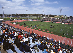
There are actually two tracks at this location, this one is the main stadium, was used for the 2000 and 2004 Olympic Trials and the 2003 NCAA Championships. This one used the two toned mondo surface to define the relay passing zones. There are 9 lanes from the 200 start area to the common finish--at this big budget facility I don't know what logic prevented them from finishing the 9th lane the rest of the way around the track. On the south end of the infield is an astroturf area that curiously has no curb--I would think that would negate the big time records set here. Mondo |
South |
8
90m
|
Aerial photo |
| California State University, Sacramento | 1998 | No | |
 North of 50 Freeway and Folsom Blvd.,
State University Drive W. and Stadium Way North of 50 Freeway and Folsom Blvd.,
State University Drive W. and Stadium WayThere are two tracks at this location, this is the training track located just northwest of the stadium. It has a 6 lane sprint straight. |
South |
2
|
Aerial photo |
| Foothill High School | No | No | |
 Hillsdale Blvd and Diablo Drive
Surrounding a Fake Grass infield |
South | 8
101m
|
Aerial photo |
| Grant High School | 2006 | No | No |
 South Ave and Fig Street
Surrounding a Fake Grass infield |
North | 6
101m
|
Aerial photo |
| Rosemont High School | 2006 | No | No |
 Kiefer Blvd. and Bradshaw Road
Blue |
South | 8
100m
|
Aerial photo |
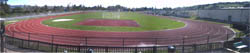
| Sacramento City College (Hughes Stadium) | Yes | Yes Inside Slice | |
Sutterville Rd. at 24th Street
This has now undergone necessary resurfacing. Steeplechase finishes reverse. Wide lanes. Start lines for 2M and some other race as yet undetermined. Cal Track Rekortan M99 |
North |
9
100m
|
Aerial photo |
Lodi |
| Tokay High School | Yes concrete |
No | |
 South Ham Lane opposite
Burgundy Lane, north of Century Blvd. South Ham Lane opposite
Burgundy Lane, north of Century Blvd.Finish line appears to be offset some 11.5 meters. They used the original 440 track curb, old dirt markings remain. Has had a new layer put on and has been repainted, some old paint can be seen through. The resurface drained through the old concrete drain gaps. |
North | 9
100m
|
Aerial photo |
Stockton |
| Delta College (San Joaquin Delta College) | Redone 2008 |
Yes metal |
Inside, adjustable |
 N. Pershing Ave. opposite Marco Polo
Dr. N. Pershing Ave. opposite Marco Polo
Dr.Fake Grass infield, redone from the ground up in March 2008. Gray passing zones. Steeplechase lane, D sector except runways also gray. There is a negotiable 10th lane most of the way around the track, used mostly for hurdle storage. Separate new throwing area south of the stadium. Mondo |
South | 9
92m
|
Aerial photo |
| Lincoln Athletic Complex |
Resurf. 2001 |
Yes metal |
No |
W. Lincoln Rd. and Alexandria Place
Northwest of Delta College. Wide Turns. There was a curb, but it was missing (the day after a meet). There is no painted inner line, not many mounting holes, just residue where the curb was. March 2008. Originally built in 1994 as Southwestern Eurotan Resurface done by Cal Tracks Cal Trax MS |
West |
8
74m |
Aerial photo |
| St. Mary's High School | 2000 | No |
No |
 N. El Dorado St. and Robinhood Dr. N. El Dorado St. and Robinhood Dr.I think this has been resurfaced since the 2000 installation which I believe was Black. This now surrounds a Fake Grass infield. Field event runways are rolled out, two of them on concrete, the third over an old black runway surface. The high jump apron is surfaced on just a portion of the D sector. There is no chute so 110 hurdles can only run 5 lanes. Green Ocean Marker Sports Surfaces |
East |
6
100.5m
|
Aerial photo |
Tracy |
| Kimball High School | 2010 | No | No |
 South Lammers Road and Jaguars Run, south of W. 11th Street South Lammers Road and Jaguars Run, south of W. 11th Street |
m
|
Aerial photo |
| Merrill West High School | No | No | |
 Lowell Avenue, west of Corral Hollow Road. Lowell Avenue, west of Corral Hollow Road. |
South | 8
100m
|
Aerial photo |
Cottonwood |
| West Cottonwood MiddleSchool | No | No | |
 Gas
Point Rd. and Della Lane Gas
Point Rd. and Della Lane |
South | 8 |
Aerial Photo |
| West Valley High School | Yes metal |
No | |
 Happy
Valley Road, north of Gas Point Rd. Southwest of town Happy
Valley Road, north of Gas Point Rd. Southwest of townSee schools aerial photo, including track Photo Gallery |
West |
8
|
Aerial Photo |
Redding |
| Enterprise High School |
2000 |
No | No |
 Churn
Creek Road Churn
Creek RoadApparently they have installed a fake grass infield Black. Finish line offset 10m |
South |
8
|
Aerial Photo |
| Foothill High School | |
No | No |
 8th Street West of Mary Street North
of school location Eureka Way (Highway 299) and Walnut Ave
8th Street West of Mary Street North
of school location Eureka Way (Highway 299) and Walnut Ave Surrounding a fake grass infield. Finish line offset 10m |
SouthEast | 8 |
Aerial Photo |
| Shasta College | Yes | No | |
 Old Oregon Trail and Collyer just north of 299 exit
9 lanes on sprint straight. Finish line offset 10m. Metal curb Track is not in the football stadium. See school photos |
South |
8
|
Aerial Photo |
| Shasta High School |
2002 |
No | No |
 8th
Street West of Mary Street North of school location
Eureka Way (Highway 299) and Walnut Ave 8th
Street West of Mary Street North of school location
Eureka Way (Highway 299) and Walnut Ave Apparently they have installed a fake grass infield. Finish line offset 17m See school's track construction page |
SouthEast |
8
|
Aerial Photo |
Shasta Lake |
| Central Valley High School | 2005 |
No | No |
 Ashby
Rd. and La Mesa Ave Ashby
Rd. and La Mesa Ave |
NorthEast | 8 |
Aerial Photo |
Mount Shasta |
| Mount Shasta High School | Old | No | No |
| Everitt Memorial Highway
opposite Shasta Ave. Rubber/Asphalt |
South |
|
Aerial Photo |
Weed |
| College of the Siskiyous | Old | No | No |

College Ave. west of the 5/97 interchange
The track is at the south end of the campus. |
South |
8
|
Aerial Photo |
Yreka |
| Yreka High School | Old | No | No |

Knapp St., 1 block west of Oregon St.
Originally a Rubber/Asphalt track was installed here in 1976, one of the first in the state. It was built metric before the National rule change anticipating metric. The track has been resurfaced at least three times since 1976. I received this nice e-mail from Jim Eckman, the retired Track Coach, describing the track. Pictures are courtesy of Ray Wolf of Siskiyou Youth. Atlas |
South |
8 |
Aerial Photo |
Fairfield |
| Armijo High School | 2005 | No | No |
 North Texas Street and
Washington Street North Texas Street and
Washington StreetSurrounding a fake grass infield |
South | 8 |
Aerial photo |
| Fairfield High School | 1996 | No | No |
 Atlantic, 1 block west of Dover, just
north of Air Base Parkway
Atlantic, 1 block west of Dover, just
north of Air Base ParkwayLook at the length of that sprint straightaway. Southwestern |
North |
|
Aerial photo |
| Rodriguez High School | 2007 | No | No |
 Ferni Drive west of Lopes
Road just south of the 680/80 Cordelia Junction Ferni Drive west of Lopes
Road just south of the 680/80 Cordelia JunctionSurrounding a fake grass infield. 8 lanes on sprint straight |
South | 6 |
Aerial photo |
| Solano Community College | Old | No | No |
In terrible condition. Hard surface, worn to powder, very inconsistent. Lane lines obliterated in many places. Curb overgrown with weeds. Soccer benches and garbage cans litter lane 1 (obviously not used for competition). When I visited this was one of the windiest locations I've ever experienced. I am told this is normal. Considering the wind conditions, without constructing a huge wall this probably isn't worth salvaging. Finish line offset 20m. Rubber Asphalt |
South Imperial |
9
100m
|
Aerial photo |
| Vanden High School | No | No | |
 Whitney Drive. and Puffin Circle, East
of Peabody Rd.
Whitney Drive. and Puffin Circle, East
of Peabody Rd.Offset finish, looks imperial from afar. Badly worn. |
South |
8
|
Aerial photo |
Vallejo |
| Vallejo High School | No | No | |
 west of Nebraska and Broadway west of Nebraska and Broadway Stadium is called Corbus Field. With a fake grass infield. There is another dirt track immediately north of the stadium. |
South | 8 |
Aerial photo |
Vacaville |
| Al Patch Park | 2006 | No | No |
 California Drive and Peabody Rd. California Drive and Peabody Rd.A public park with a competitive track facility. Looks like it has broken back turns and long straightaways. City's park page. |
Northwest | 8 104m |
Aerial photo |
Vallejo |
| Vallejo High School | No | No | |
|
west of Nebraska and Broadway Stadium is called Corbus Field. With a fake grass infield. There is another dirt track immediately north of the stadium. |
South |
8 |
Aerial photo |
Petaluma |
| Petaluma High School | Yes | No | |
 Fair Street where it turns into 10th
Street at Douglas Street Fair Street where it turns into 10th
Street at Douglas Street |
Southeast |
8 |
Aerial photo |
Rohnert Park |
| California State University, Sonoma | Yes Inside | ||
 Cotati Ave. at the east end where it
meets Petaluma Hill Rd. Cotati Ave. at the east end where it
meets Petaluma Hill Rd.This track is so old, it has two different colors visible. Finish line offset 21 meters. |
South |
|
Aerial photo |
Santa Rosa |
| Elsie Allen High School | Yes metal |
No | |
 Bellevue Ave. and Stony Point Road Bellevue Ave. and Stony Point RoadWhile relatively new, the subsurface of this track seems to be moving, or paving seams were not done well. There are many, large cracks, most going exactly in the running direction or perpendicular to them. If ever a paving company might get sued for poor work, this sure seems like the case. Perhaps they did not do a geologic survey of this location first and it is moving. This will have to be redone completely when they get sufficiently frustrated with the cracks. |
North |
9
100m |
Aerial photo |
| Cardinal Newman High School |
2002 |
No |
No |
 Ursuline Road and Old Redwood Highway,
just south of Mark West Springs Road Ursuline Road and Old Redwood Highway,
just south of Mark West Springs RoadCal Track Cal Trax MS |
South |
6
100m |
Aerial photo |
| Santa Rosa City College | Resurf. 2001 |
No |
Yes inside slice |
Mendocino and Pacific
There are two tracks at this location, the northeast track with a steeplechase is the college. The southwest track with a fake grass infield is the High School. There is much more security fencing protecting the noticibly older track at the College. Lots of pock marks from repairs. Cal Track Cal Trax MS |
South | 8
100m
|
Aerial photo |
| Santa Rosa High School | 2003 |
Yes metal |
No |
Mendocino and Pacific There are two tracks at this location, the northeast track with a steeplechase is the college. The southwest track with a fake grass infield is the High School. |
North | 8
100m
|
Aerial photo |
Sebastpol |
| Analy High School | No | No | |
|
Johnson St. and Sunset Ave.
Black |
West |
8 |
Aerial photo |
Sonoma |
| Sonoma Valley High School | No | No | |
 Broadway and E. MacArthur Broadway and E. MacArthurBlack |
East | 6
100m
|
Aerial photo |
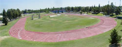
Modesto |
| Modesto Junior College | Yes | Adjustable, Inside | |
Tully Road and Coldwell
Home of the famous Modesto Relays. Tight turns. In order to put the finish in front of the fans in the stands; Finish line is offset 19m. Steeplechase finishes in reverse. Blue was Southwestern Eurotan |
South | 9
110m
|
Aerial photo |
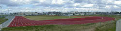
Oakdale |
| Oakdale High School | 2006 |
No |
No |
 View Larger Map Bryan Ave. and J St. Surrounding a Fake Grass infield. Here's a nice website dedicated to the construction of this facility, though primarily devoted to the field. There is no discussion on how they arrived at the number of 7 lanes, but apparently it is the lack of width between the old stands. These are the longest straightaways (meaning the tightest turns) I have seen. All field events are concentrated in the north end of the stadium. Cal Track |
South | 7
116m
|
Aerial photo |
Turlock |
| California State University, Stanislaus |
(No) |
Adjustable, Inside | |
Geer Road and Calaveras Way, north of
Monte Vista Ave.
Has a curb all the way around the track, but it never reaches the 5 cm required and dips below the track surface in some places. |
South |
9
100m
|
Aerial photo |
Erie |
|
Beale Air Force Base |
2006 | No | No |
| Warren Shingle Road and
A Street United Sports Surfaces |
8
m
|
Aerial photo |
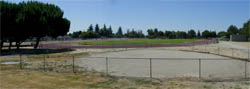
Yuba City |
|
Geweke Field |
No | No | |
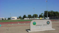 Hwy. 99 north of Bridge
St., West of Gray Ave. due to be resurfaced. |
North |
8
90m
|
Aerial photo |
|
River Valley High School |
2007 | No | No |
Lassen Blvd. and Harter Road Surrounding a fake grass infield |
South |
m
|
Aerial photo |
|
Yuba City High School |
2007 | No | No |

Clark Avenue and Franklin Avenue Surrounding a fake grass infield |
South |
m
|
Aerial photo |
Red Bluff |
| Red Bluff High School | No | No | |
 Spartan
Ranch Road east of Baker Road Spartan
Ranch Road east of Baker RoadSchool is on Douglas Street. !!Has barricades. This now marks the second track I have seen that is Green Atlas |
South | 8
100m
|
Aerial photo |
Exeter |
|
Exeter High School |
2004 | No | No |
| Rocky Hill Dr. and Kaweah
Ave. (Hwy. 65) |
South |
9
100m
|
Aerial photo |
Porterville |
| Porterville Community College | No | Yes, Inside | |
|
College & Main, south of Highway 190
|
South |
|
Aerial photo |
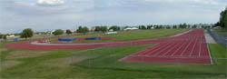
Tulare |
| Tulare High School (Bob Mathias Stadium) | mid 80's | Yes concrete |
No |
Tulare Ave. and Cherry Black Concrete curb. Finish line offset 10m. |
South Imperial |
9
100m
|
Aerial photo |
Visalia |
| College of the Sequoias | late 60's or early 70's | No | No |
Woodland & Meadow
The four lane track is the narrowest track intended for competition in the state. Blue Tartan |
North Imperial |
4
|
Aerial photo |
| Central Valley Christian High School | 2006 | No | No |
 Tulare and Akers Finish line offset 10M !Protected by high bar wire fences. There is an unmarked 9th lane all the way around the track, but it is only surfaced to the middle of the lane, the outside of the obviously unused lane is pavement. The coloring on this track is unique. Black with speckles of mostly white, but some blue and red. |
South | 8 99m |
Aerial photo |
| El Diamonte High School | 2006 | Yes concrete | No |
 Tulare and Whitedale A broken back track with wide turns and short straightaways. And yes, a new track built with a proper concrete curb with drain gaps about every 5 feet. Other than extending the outfield for the third string baseball field, I can see no geographic reason why they built such a short, fat stadium or a broken back track within it. This is the first place I have seen the horizontal jump runways numbered, the west LJ runway is 1, the east TJ runway is 2. Both runways seem short, about 100 feet (particularly bad for triple jumpers). Both runways are set into the grass area over 20 feet, so the wide width that might be for soccer is negated. The runways all jump to the north, but the sprints finish to the south. Marked for 400H. |
South | 9
79m |
Aerial photo |
| Golden West High School | 2005 | Yes metal |
No |
Mcauliff and Houston Ave. Yes, a real metal curb at a high school track. I will say I like the soft natural grass on this infield. And on the east edge of town it is unique to hear horses whinnie nearby. ! High slat fencing make this difficult to get into. Atlas |
South | 9 101m |
Aerial photo |
| Mt. Whitney High School | 2005 | No | No |
Tulare and Conyer Just six blocks down the street from Redwood H.S. 9 lanes on the sprint straight. |
East | 8
102m |
Aerial photo |
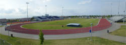
| Redwood High School | 1991 | No | Inside, fixed |
Mineral King and Conyer
The stadium here is built into a bowl. |
East |
9 100m
|
Aerial photo |
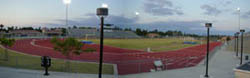
Davis |
| Davis High School | 2009 |
Yes | Yes |
 Covell Blvd. and Oak Ave. Covell Blvd. and Oak Ave.Surrounding an fake grass infield with wide turns. |
South | 8 75m |
Aerial photo |
| University of California, Davis | Yes | Yes | |
 Russell and A Street Russell and A Street Finish line offset 10m !Gates are often locked and the staff here is most unfriendly to outsiders using the track. |
South |
8
99m
|
Aerial photo |
West Sacramento |
| River City High School | 2008 | No | No |
Jefferson Blvd. and Linden Road Surrounding a fake grass infield. |
South |
8 |
Aerial photo |
Marysville |
| Yuba Community College | Yes | ||
N. Beale Street and Alberta Ave.
The finish line appears to be offset by around 20 m. |
West |
8
|
Aerial Photo |
Wheatland |
| Wheatland High School | No | ||
| Wheatland Road, south of
Olive Street, west of G Street |
Southwest | 8 |
Aerial Photo |